
A Break Away From the Hustle & Bustle
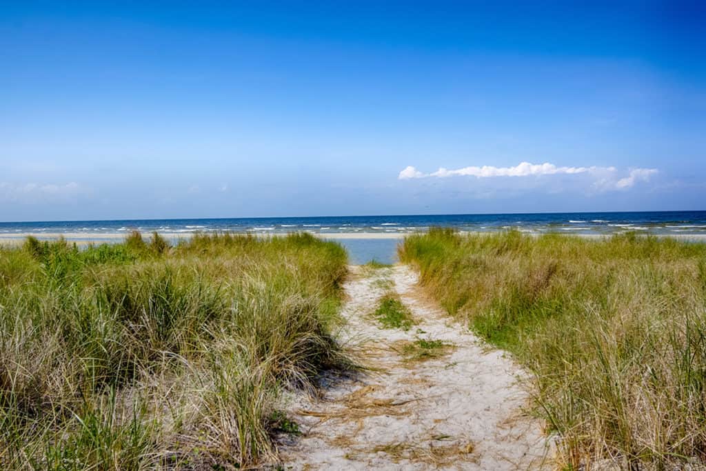
Made up of 15 communities, Down East refers to the rural waterfront communities east of Beaufort, beginning at the North River Bridge and offers a variety of vacation rental homes. The main highway (highway 70) has been designated at part of the NC Scenic byway, and for good reason. Breathtaking scenery and a slower pace of life offer the perfect retreat from the hustle and bustle of daily life.
Down East is known for its strong fishing heritage, including shrimping & clamming and boat-building. The landscape is lined with salt marshes and provides the perfect setting for bird watching. It is also the main access point for visiting Cape Lookout National Seashore & Shackleford Banks.
 At the furthest point on Harkers Island, you can load up on your history by visiting the Core Sound Waterfowl Museum or book a ferry ride to Cape Lookout National Seashore or Shackleford Banks.
The Core Sound Waterfowl museum offers one-of-a-kind insight into the history of Down East. Immersed in the rich heritage of wood duck carving and the fishing heritage. You might also enjoy learning about a brogue, unique to Down East and the Outer Banks, known as the “Hoi Toiders” dialect.
Pack a lunch and sunscreen and enjoy a day exploring the untouched beaches of Cape Lookout National Seashore and the iconic lighthouse aptly named the “Diamond Lady”. Or, grab your water shoes and enjoy a guided tour along the shore of Shackelford Banks, where you’re sure to catch the wild horses playing.
Contact Us today and let us help you create the perfect Down East vacation!
About The Communities

Bettie
Bettie, which is also known as the “Gateway to Down East”, is the first community on Highway 70 East after crossing North River Bridge (coming from Beaufort). Bettie was originally named Simpson according to early records. The community is primarily a farming and fishing community, with the descendants of the early settlers still living there today. Bettie is known for Simpson Greenhouse and farm which sells some of the county’s best fresh local produce, such as strawberries, tomatoes, corn, and other seasonal vegetables.
Otway
Otway, located after Bettie, is the second community on Highway 70 East after crossing North River Bridge (coming from Beaufort). The community was originally settled in the 1700’s, but later named after one of Carteret County’s most famous residents, Otway Burns, a ship captain and privateer around the time of the War of 1812. Locally, Otway is known for its farm produce of sweet potatoes and collards. Many residents also still make their living off the water and one can often see them clamming or oystering in Ward’s Creek along Highway 70 East. Otway has several stores, a large bed and breakfast, and a large campground with swimming pool for RVs.
Smyrna
Smyrna is located at the junction of Highway 70 East on the left, leading to Cedar Island, and on the right, the road leading to Marshallberg. The community was settled around 1700, but had a number of names until 1853, when the community was actually named Smyrna. One of “Down East’s” three elementary schools is located in Smyrna. Smyrna also is home to Eastern Park which provides recreational activities, such as baseball, tennis, and basketball, and also features a children’s play area. The community is also home to the Crissie Wright Lodge and has a number of businesses located along Highway 70.

Gloucester-Straits
Straits Township, which encompasses the community of Gloucester, was settled as early as the pre-Colonial period by commercial whalers and fishermen from the Chesapeake Bay and New England areas. After a sea journey by Capt. Joe Piggott, Gloucester was named after Gloucester, Massachusetts in 1904. The communities are primarily residential, with fishing and boat building and boat repair still serving as traditional occupations. Construction, recreation, and saltwater activities are the primary businesses.

Harkers Island
Harkers Island is located approximately 17 miles from downtown, historic Beaufort. Sometimes referred to as “the island of refuge”, many of the inhabitants are descendants of earlier descendants left the more precarious islands just across the sound.
There was no bridge connecting Harkers Island to the mainland until the early 1940’s. The resulting isolation helped Harkers to retain a rich and unique history among its watermen who still today speak in a brogue with charming Elizabethan English tones. Custom boat building and fishing, as well clam, crab and oyster harvesting have been longstanding means of sustenance for the islanders.
The 21st century finds Harkers Island as a fisherman’s and boater’s paradise. The pristine waters of Back Sound connect Harkers Island to The Cape Lookout National Seashore and the Cape Lookout lighthouse and wild horses. Ferries are readily available from Harkers Island for shuttling visitors to the National Seashore.
The Core Sound Waterfowl Museum and the annual Decoy Carvers Festival are among other of the islands distinctive attractions. Artisans from Harkers Island are renowned for their wooden decoys and handcrafted boat models.


Marshallberg
Marshallberg is located along Sleepy Creek, near Gloucester, in the middle section of “Down East.” During the pre-Civil War era, Marshallberg was originally called Deep Hole Point because of the huge hole in the Sleepy Creek creek bed which was excavated to provide soil for construction of the ramparts at Fort Macon. Marshallberg has traditionally been a fishing and farming community, with Marshallberg Harbor serving the fishing community. The community has one small grocery store, a volunteer fire department and a beautiful picnic area overlooking the water from which Cape Lookout Lighthouse can be seen.

Williston
Williston is located between Smyrna and Davis along Highway 70 East heading toward the northern part of “Down East.” One of Williston’s earliest settlers, John Jarrott, received a land grant from King George in 1719 for the area which now includes Williston. Jarrett Bay was named after John Jarrott. A seafood plant specializing in clams was opened in Williston during the 1920s and Williston soon gained a reputation as North Carolina’s “clam capital.” Williston features a small commercial garden center, stained glass shop, and small art gallery.

Davis
Davis is located between Williston and Stacy along Highway 70 East. The community was settled as early as 1752 according to old land grants. Traditional occupations of farming, fishing and fishing-related activities, such as net making, are still prevalent in Davis today. Alger’s Ferry in Davis provides ferry services to Core Banks and Alger’s fishing camps. There are several small stores in Davis, as well as a volunteer fire department. Eastern Gateway Realty also maintains a small information booth along Highway 70 East in Davis.
Stacy
Stacy is located between Davis and Sea Level along Highway 70 East heading toward the northern part of “Down East.” Stacy is bordered by Core Sound and Nelson Bay as well as Open Grounds Farm on the north and east. Open Grounds, comprised of 32,000 acres, is one of the largest farms in the country and the world and produces soybeans, cotton and corn. The area is known for its abundance of wildlife including many deer and one can often see geese and swans in the waters off of Highway 70 East in the Stacy area. Farming and fishing are traditional occupations.
Sea Level
A location perfectly represented by its name. This is the lowest area of land in Carteret County. The area originated as one of “The Hunting Grounds” in 1702 by Captain John Nelson. It was known for its plethora of game, fish and oysters. The same is true for today as you will find many folks out in Core Sound gathering their fruits of the sea.
Cedar Island
Located at the end of our county, this community offers boat ramps, NC Ferry (Click here for ferry schedule) service to Ocracoke Island, grocery shops, a post office, and horseback riding services. A wonderful place to get away and explore the coastal waters where the Pamlico and Core Sounds meet. Most of the area is the Cedar Island Wildlife Refuge where you may hike near the end of Lola Road.